When all of the factors have been transformed into boolean images (i.e., reduced to constraints), they are ready to be aggregated. In this section of the spatial analysis, the MCE - Boolean operation is used. I used this operation because it allows me to input any number of constraints which will be multiplied together to produce a single image of suitability. This procedure is equivalent to a logical AND operation and is accomplished by using a series of OVERLAY multiple operations.
Please see Methodology for a more in depth description of this procedure used in generate a final image
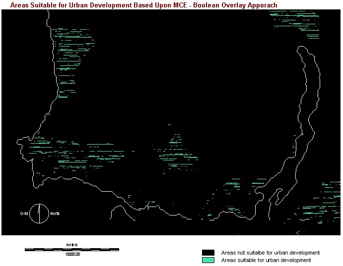
According to the image below, areas indicated in black shows locations that not suitable for urban development at all. While areas indicated in green shows locations that can be considered for potential urban development of the North Shore Mountains. As expected, areas that are considered suitable for urban development compared to the LANDCON.rst image.
The following resultant image is the result of using The Boolean Overlay Approach - MCEBOOL.rst
Result Assessment/Comment of the MCE - Boolean Overlay Analysis:
A value of 1 in the final suitability image was only possible where all 7 constraint criteria (please see Methodology for the list) also have a value of 1, and a value of 0 was the result if even one criteria has a value of 0. In this case, suitability in one criteria cannot be compensated for a lack of suitability in another. In other words, they did not trade off. In addition, because the Boolean MCE analysis is a logical AND (minimum) operation, in terms of risk, it is very conservative. Only by the exact meeting of all criteria is a given location considered suitable for urban development in the North Shore Mountains. The results displayed above are the best location possible for urban development and no less suitable locations were identified
These proprieties of no tradeoff and risk aversion may be appropriate for
many projects. However, in reality, the criteria should compensate for
each other. Urban planners are not just interested in extreme risk aversion.
For example, a location close to open water bodies (urban development not
suitable when considering this one criteria) might be an excellent location
in all other aspects. Even though the location may not be the most suitable,
one may want to consider it suitable to some degree. Therefore, by performing
the MCE - Weighted Linear Combination (in the next section of this project),
the determination of the location of areas in terms of its degree
of suitability for urban development in the North Shore Mountains area
is possible.
Click here
for Weighted Linear Combination (4.2)
Or click here to go back to main menu